Teacher Notes in Yellow
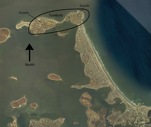
The Northern section of Hull is a classic tombolo, a connection feature caused by sand depositing between two drumlins. Drumlins are very common in the Boston area; most hills in the area are, in fact, drumlins.
We used Google Earth to exaggerate the elevation on the map to show the drumlins more clearly.
The drumlin on the East (Allerton Hill - on the left in the bottom picture) has been cut by ocean currents and wave action. It is a good challenge for the students to consider what different processes might cause the hill to be cut. Could it have been human actions? Why not?
Note that the direction is flipped between the two pictures. While that could be confusing, we wanted to show the typical view of Hull (in the first picture, with North pointing up), but in order to show the cut in Allerton Hill we needed to rotate the map. (This could be a good lesson in perspective in map reading for your students!)
Below, you see a picture of Hull. Along the Northern part of the town, there are two drumlins. A drumlin is a hill composed of a pile of sand, rocks, gravel, boulders, etc. that have were left behind as glaciers retreated over 12,000 years ago. One interesting thing about this particular spot is that the drumlins are connected by sand. This connecting feature is known as a tombolo.
Usually drumlins have a very regular oval shape. If you click on the picture below, you can see a larger version of the tombolo. The elevation has been exaggerated to show the two drumlins. Notice in the larger version that one of these hills (on the left) seems to have been cut at a very steep angle. What are some different reasons why this may have happened?